After some initial quadcopter sketchiness – mainly a yaw problem that I think was the result of a loose rotor – and a couple of crashes, I completed two successful flights this afternoon down in the wetlands, after which college police offered me a ride up to campus, my first time in the back of a police car.
The next step in the project involves getting the images into the GIS. Jason Pittman (Geosciences) is close to perfecting that process, and will be sharing it here in the next week or so. In the meantime, I decided to search the web for free software to accomplish the same task, and stumbled upon http://mapknitter.org, which is a sub-project of the fabulous Public Laboratory for Open Technology and Science, at http://publiclaboratory.org.
The Public Laboratory for Open Technology and Science (Public Lab) is a community which develops and applies open-source tools to environmental exploration and investigation. By democratizing inexpensive and accessible “Do-It-Yourself” techniques, Public Laboratory creates a collaborative network of practitioners who actively re-imagine the human relationship with the environment.
In a process that I’ll document in more detail soon, I was able to correct the GoPro Hero2’s fisheye distortion using Adobe After Effects. I then brought the corrected images into Map Knitter and aligned them to Google Maps using a combination of scale, rotate, and skew. The software is intuitive, and exports in a variety of formats, including OpenLayers, TMS, OSM-style TMS, GeoTIFF and JPG. Here’s my first take – it’s not perfect, but it’s a start.
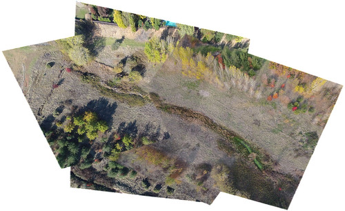
You can view the map in context at http://mapknitter.org/map/view/2012-11-27-flc-wetlands.
[…] Details here: http://www.dolookdown.org/2012/11/28/map-knitter-open-source-diy… […]
[…] uploaded the photos to Google Drive, and over the next week, students will use Map Knitter to stitch the photos together and georeference them. All things considered, a successful […]